Drone photography has become increasingly popular, especially in real estate, construction projects and land marketing. Visual content has a direct impact on how effectively a property stands out online and how quickly interest turns into contact. This expert article discusses what all drone description includes how its price is formed, and how you can order the photo shoot easily - cheaply and quickly throughout Finland.
Whether you are a real estate agent, construction company, municipal land manager or production company, you will find essential information, examples and procedures in this comprehensive guide. It includes concrete price examples, delivery processes and visual recommendations to help you make an informed decision about ordering drone photography.
Read more:
- Real Estate Drone Photography in Finland – Prices, Benefits and Competition >>
- Drone photography cheaply and quickly – Order all over Finland >>
- Real Estate Drone Photography in Finland – Prices, Benefits and Competition >>
- Drone photography and drone images >>
The article answers the following questions:
- What does drone photography involve?
- What affects the price of drone photography?
- How quickly can drone photography be delivered?
- How to easily order drone photography?
- For which purposes is drone photography most beneficial?
- How to avoid permit risks and regulatory errors?
- What is the best way to hold a drone photography competition?
- How does Visu24 differ from other service providers?
- How much does drone photography cost in different locations?
- How do you ensure a successful outcome?
Drone photography – What is included in the service?
Drone photography typically includes more than just a single aerial image. The photography ordered through Visu24 is designed to meet the needs of marketing, planning and documentation – efficiently, visually and without hidden costs.
How is drone photography carried out?
Drone photography is usually carried out as a 1–2 hour fieldwork, during which the following is recorded:
- 5–10 overhead shots from different angles
- 5–10 street-level photos and close-ups
- 1–2 short video clips (approx. 10–30 seconds each)
- possible 3D observation embedding in the plan provided by the client
All material is delivered post-processed (colors, contrast, cropping, packaging), completely ready to use.
What does the customer get ready-made?
The delivery package includes:
- JPG and/or PNG images in high resolution
- Videos in MP4 format
- Raw files of still images can be provided separately if desired
- Ready-made files are suitable directly for websites, brochures and sales announcements
The price of the photo shoot also includes the right to use the images without license restrictions – the customer can use the images freely in marketing, project reports or publications.
In which situations does drone photography bring the most added value?
The service is particularly suitable for:
- real estate sales and rental advertisements
- for marketing plots or illustrating zoning
- documenting progress on construction sites
- stakeholder communication for public projects
- as a background for design and architectural images
The drone imagery available through Visu24 is scalable – whether it's a single object or a larger entity.

Visu24 customer experiences:
- Professional cooperation with Visu24: Photorealistic 3D images bring architecture to life >>
- Visu24 implemented 3D modeling and video adaptation for Energiequelle's wind power projects for the EIA procedure and landscape impact assessment >>
- Swedish Havsporten Karlholm Strand AB thanks Visu24 for successful 3D visualizations for a villa project>>
- Visu24 and Honka Japan promote Finnish log construction to the Japanese >>
- Valiotalo's experiences with Visu24 >>
- Olas Group Oy's Henri Mattila's experiences with Visu24 >>
Drone photography price – What does the price consist of?
The cost of drone photography is not just the duration of the flight or the number of photos – it is made up of many factors that directly affect the total cost. This section explains what drone description actually consists of and how different factors are reflected in the customer's price.
Key price components
The following elements are typically included in the price list for drone photography:
- Description and equipment: photographer's work, professional drone, backup equipment and batteries
- Post-processing: image and video editing, cropping, color grading
- Travel expenses and location: distance to the destination often affects the price
- Photography permit and airspace restrictions: possible special permit that requires contact with authorities
- Additional services: 3D observational immersion, graphical addition of plot boundaries, music for videos
Taking the above into account, a photo shoot can cost from a few tens of euros to several hundred euros, depending on the subject and requirements.
Example prices for different photography locations
| Target type | Price from (VAT 0%) |
|---|---|
| Town house | 199 € |
| Terraced house or apartment building | 250 € |
| Plot, with boundaries | 199 € |
| Construction site (day) | 600 € |
| 3D observation immersion + images | 450 € |
All prices include basic photography, light editing, and usage rights to the submitted material.
When does drone photography cost more?
The price will increase if:
- the object being photographed is located near the airport
- weather conditions require special arrangements
- the images are to be used for special productions (e.g. as background material for an advertising film)
- Delivery is required urgently for the next day
Visu24 prices its services clearly and always as agreed in advance - there are no surprise bills.

Read more:
- Visualization to support sales – How 3D images speed up decision-making >>
- Station Drawing – Price, Content and Instructions: Everything You Need to Know >>
- The best free floor plan and floor plan drawing programs >>
Drone photography quickly – How fast is delivery?
One of the most important reasons to choose to order through Visu24 drone description is the speed of delivery. The need to photograph a property, construction site or plot can arise unexpectedly - in this case, it is important that the service provider is able to deliver the footage promptly and without unnecessary intermediaries.
What is the schedule for drone filming?
Visu24's network-based model allows you to arrange a shoot with 1–3 business days' notice. Once the location, desired schedule, and type of shoot have been specified, the photographer is automatically selected based on availability and expertise.
- Proofs are usually available within 3–5 business days.
- Quick projects (e.g. property sale announcement) even for the next day
- Evening and weekend shoots also possible by separate agreement
The delivery schedule is always confirmed before work begins and remains as agreed – without delays.
What happens immediately after ordering?
- Order confirmed automatically by email
- Photographer booked Visu24's network by location
- The filming will be carried out on the agreed day
- Finished materials are delivered with a download link (WeTransfer or Google Drive)
What are the ways to speed up delivery?
- All information in one form: no unnecessary back and forth messages
- Automatic graph selection: faster resource allocation
- Standardization of file formats: no conversion needed on the client end
- One-person filming teams: no need for a separate observer or logistics
The operating model developed by Visu24 minimizes manual work, maximizes efficiency, and makes fast delivery of drone photography the standard, not the exception.
Read more about modeling:
- 3D modeling – what are its benefits in the construction industry? >>
- 3D visualizations for new developments. Discover our selection now! >>
Drone photography in real estate marketing – Why does it work?
A well-executed drone photography significantly raises the level of marketing of a property. Buyers and renters make their first choices online, and visual first impressions are crucial. A property photographed from above gives an overall picture of the plot, surroundings, views and proportions – things that interior photos or photos taken from street level do not reveal.
What are the benefits of drone photography in selling a property?
- Better first impression: A professionally photographed item immediately stands out from the competition.
- Higher click-through rate: Aerial photos attract more interest.
- Faster time to sale: According to research, properties with drone photos sell up to 68% faster.
- Buyer confidence increases: The images show the location, boundaries and surroundings, which reduces uncertainty.
- Show the attractiveness of the area: A location near a body of water, park or services is effectively highlighted from the air.
What kind of marketing is drone photography best suited for?
- Detached houses and beach resorts: Show views, beach and placement of buildings on the plot.
- Apartment buildings: The aerial view illustrates the block structure and the surrounding area.
- New sites and architectural sites: Visually striking objects benefit from a bird's eye view.
- Plots and undeveloped land areas: Allows for understanding of purpose and boundaries.
Videos for property presentation
Short aerial videos make a subject come alive and professional. In one shot, the drone's camera can showcase the environment and subject with natural movement. This type of content works especially well for:
- on the home sales website
- on social media (e.g. Facebook, Instagram, YouTube)
- in real estate portal advertisements
Drone photography for construction project documentation
Drone photography brings transparency and efficiency to the documentation of construction projects. With aerial images, the progress of the project can be monitored visually and in real time without the burden of heavy on-site reporting. This serves both contractors, project managers and clients.
Why does drone photography work for construction site monitoring?
- The entire construction site in one picture: Wide, top-angled shots show the whole picture at a glance.
- Timeline and progress tracking: Aerial photos can be taken at certain intervals and different phases can be visually compared.
- Information and reporting: The images serve as documents for, for example, financiers, the city or shareholders.
- Inspection and error detection: For example, the location of warehouses, traffic control and security arrangements are clearly visible.
Drone photography is particularly useful in large projects where ground-level photographs alone are not enough to provide an overall picture of the situation.
What can construction site documentation contain?
- 2D aerial photos of different construction phases
- Video footage of the construction site progress
- Plot demarcation and placement of buildings on the map
- Visual monitoring of material inventories and logistics
- Image series suitable for verifying invoicing and project phases
Example of a shooting schedule
- Introductory description before the foundations
- Weekly photos about the different stages of the construction site
- Finished stage description before handover
The entire material package can be compiled into a PDF report that presents the progress of the site in chronological order. This also facilitates regulatory inspections and compliance with documentation requirements.

Read more about our services:
- 3D images for new properties 24/7 >>
- 360 photos for pre-marketing and sales campaigns from Visu24 >>
- 3D floor plans and drawings from Visu24 >>
- We also do 3D animations >>
- 3D tour: Sell your new property faster with a 3D tour >>
- A new property introduction video helps you sell your new property faster >>
- 3D exterior visualization helps sell your new property faster >>
Plot and area description – Show location at a glance
When it comes to marketing a plot of land or a large area, drone photography offers a superior way to illustrate the location, shape and surroundings. When photographed from above, the boundaries of the plot, the possibilities for use and the neighborhood are clearly outlined – especially when graphic elements are added to the images.
How does drone photography help in presenting a plot of land?
- A clear view of the plot boundaries and shape
- Distances to roads, waterways and services are illustrated
- Possibility to highlight the construction site, routes and environmental values
The following can also be added to aerial images via Visu24:
- Boundary lines and dimensions
- Info boxes (e.g. building rights, area)
- Map coordinates and direction arrows
This makes the presentation of the plot much more impressive, especially in electronic communications and in connection with zoning.
Purposes of plot description
- Sales announcements and marketing brochures
- Zoning materials and zoning reviews
- Investment presentations for municipalities and investors
- Attachments to building permit applications
Drone photography also enables before-after comparisons of, for example, forest clearing, civil engineering or area development phases.

Read more about the benefits of 3D visualizations:
- How to speed up the sale of your new property with new property visuals >>
- How 3D modeling makes it easier to sell your new property >>
- A virtual tour makes it easier for your customer to make a purchasing decision >>
- 3D rendering of the exterior speeds up the sales process >>
Drone photography and safety – What licensing issues should be considered?
Drone photography brings visibility and efficiency, but at the same time requires a detailed knowledge of regulations. In Finland, drone photography is governed by common EU regulations, which are monitored by Traficom. Visu24 takes care of all permit issues for you, so you can focus on the real thing – utilizing the footage.
Where is drone photography allowed and where is it not?
Finland is divided into three zones according to airspace restrictions:
- Inner airport zone: Flying is only permitted with permission from air traffic control
- Middle zone: Maximum height 15 m above obstacle
- Outer zone: Flying permitted up to a height of 50 meters
In addition, there is permanent exclusion zones as:
- Nuclear power plants
- Prisons
- Defence Forces targets
- Official residences of the Prime Minister and the President
Visu24 always checks airspace restrictions in advance and obtains the necessary permits.
Registration and qualifications
Operators using drones weighing more than 250 grams must be:
- Registered in the drone operator register
- Have completed the online theory test (A1/A3 or A2)
- Insured for liability damages
All Visu24 photographers meet these requirements.
Data protection and privacy
Drone photography must not be directed at areas where domestic peace or privacy is violated. Therefore:
- People's faces are not depicted in a recognizable way without permission
- Description of private courtyards is only permitted if the subscriber owns the item or has consent to it
- Separate permission is required for publication of images, if necessary.if there are other people or buildings in the pictures
Visu24 complies with EU and Finnish data protection legislation in all assignments.
Drone photographer or ready-made service – Which one should you choose?
Drone photography can be obtained either by finding a photographer independently or by using a ready-made service model, such as Visu24. Both models have their advantages, but the differences are particularly visible in ease, quality assurance and delivery reliability.
What is the difference between searching yourself and the Visu24 service?
Option 1: Autonomous drone photographer search
- The requirement to compete and compare yourself
- Assessing quality and competence is difficult without references
- Schedules and pricing may vary greatly
- The responsibility for checking permits and liability issues lies with the customer.
Option 2: Visu24-ready service
- One form → selected photographer from one of Finland's largest networks
- Delivery in 3–5 business days
- Price and scope are clearly agreed upon before the shoot.
- Permits, insurance and liability issues are taken care of for you
- Guarantee that you will always receive ready-to-use, high-quality material
Which one is suitable for whom?
- For project managers and busy experts: Visu24 offers ease of use
- For advertising agencies and real estate companies: Consistent production and reliability
- For private customers and first-time customers: Support and guidance make the purchase decision easier
What does Visu24 do for you?
- Photographer selection and booking
- Coordination of filming
- Editing and finishing
- Permits and regulatory requirements
- Access rights statements
- Material delivery and archiving

Aerial photos, videos and 3D imagery – What can drone photography include?
Drone photography is not just about a single overhead shot. When done well, it can include a diverse package of visual material that serves a variety of purposes. Visu24 offers a service that combines still images, aerial videos, and 3D observational embeddings – all from the same object, through a single order.
Three perspectives on the same object
1. Aerial photos from an angle or directly above
Show plot boundaries, building layout, and environmental context.
2. Aerial videos with a moving camera
They provide a dynamic, professional overview of the property. Especially used in real estate and new property marketing.
3. 3D observation images embedded in an aerial background
3D models provided by architects or developers can be placed in the real landscape, allowing the future site to be seen realistically before it is even built.
What are the different materials used for?
- Still images → websites, brochures, real estate portals
- Video → social media, YouTube, advertising campaigns
- 3D visualizations → zoning, building permit applications, stakeholder communication
All materials produced by Visu24 are delivered pre-edited and ready to use. Videos can also be delivered finished with the client's brand colors and font styles.
Drone photography price and pricing models – How much does the service cost?
Drone photography can be a simple, quick operation or a larger production. Visu24 offers clear pricing models based on the scope of the photography, location and elements used. In this section, we will go through the most common pricing models and what the drone photography price consists of.
What is the price of drone photography?
- Location and accessibility of the site
Remote locations or locations requiring special permits may increase costs. - Number and type of images
Just shooting 5–10 still images is more affordable than a combination of videos and 3D elements. - Editing and post-processing
Color grading, cropping, soundtracks, and graphic elements are usually included in the price with Visu24. - Travel costs and local availability
Visu24's network covers all of Finland, so travel expenses are minimized by choosing a close-up photographer.
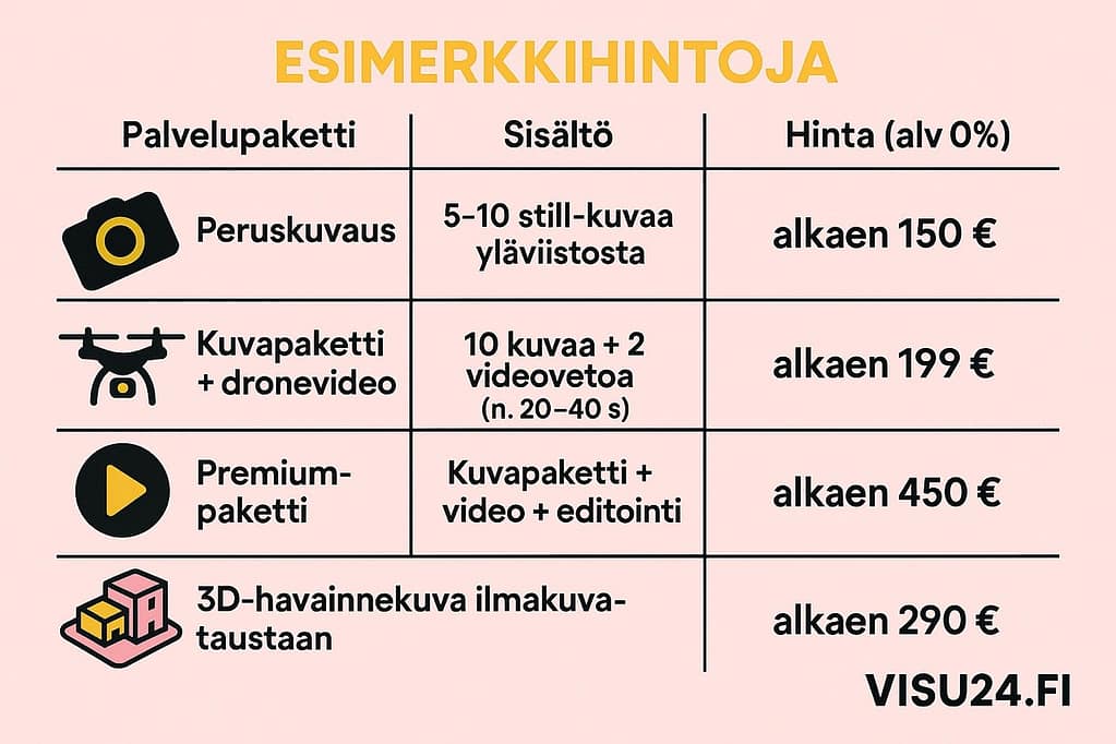
Sample prices
| Service package | Contents | Price (VAT 0%) |
|---|---|---|
| Basic description | 5–10 still images from the top angle | from €150 |
| Photo package + drone video | 10 images + 2 video shots (approx. 20–40 s) | from €199 |
| Premium package | Photo package + video + editing | from €450 |
| 3D visualization for aerial photography background | An illustrative image that is embedded in a drone background | from €290 |
All prices include delivery within 3-5 business days. For urgent cases, a separate express schedule is offered.
What do you get for your money from Visu24?
- Professional photographer's work + spare equipment
- Permits and insurance taken care of
- Shooting, editing and delivery ready to use
- License for commercial use
- Visu24 customer support and satisfaction guarantee
Drone photography delivery time and delivery methods
Delivery time is one of the most important factors when ordering drone photography. Visu24 focuses on speed and reliability – the goal is to deliver ready-to-use material quickly, but without compromising on quality. This section explains how the delivery process works and what you can expect.
How quickly is the drone footage delivered?
In most cases, the delivery time is:
- Impressions: 2–3 business days from the shoot
- Finished material: 3–5 business days
- Express delivery: available by separate arrangement (1 weekday)
Delivery times may vary depending on the location of the item, weather conditions and the scope of the service package. Visu24 will reserve a replacement day if necessary, for example in case of rain, and will notify the customer immediately of any delays.
How are the materials delivered?
All images and videos produced through Visu24 are delivered via a digital download link. We usually use WeTransfer or Google Drive. The delivery package includes:
- Pre-processed jpg images (full-size and lighter versions)
- Videos rendered in 4K resolution (in mp4 format)
- Possible graphic elements or overlays
- The delivery archive is backed up for 6 months.
In addition, the subscriber can optionally receive a license document for the images and an image quality review report.
What time should I book a photo shoot?
Most shoots can be completed with 2–5 days' notice. In urgent cases, we can often complete the shoot the very next day – especially in the capital region and larger cities, where photographers are available at short notice.
Tip: During high season (spring, early summer), it is recommended to make a reservation 5–7 days before the desired shooting date.

Buy drone photography from Visu24 – easily, quickly and reliably
When you want affordable and high-quality drone photography, Visu24 is the right choice. We combine local professional photographers, clear pricing and fast delivery – without any unnecessary effort on your part.
Why Choose Visu24?
- Finland's most comprehensive photographer network – filming can be done quickly almost anywhere
- Transparent pricing and free quote request
- Filming, editing and delivery in 3–5 business days
- Friendly and knowledgeable customer service
Whether it's a sales property, a construction project or a flight inspection - we can provide you with drone photography quickly and competitively.
Request a quote today: visu24.fi/pyda-tarjous
Drone photography is no longer a luxury – it is a modern basic solution that allows your target stands out, inspires trust and makes an impression.
Visu24 – Show the world what your property really looks like.
How to order:
Read more: