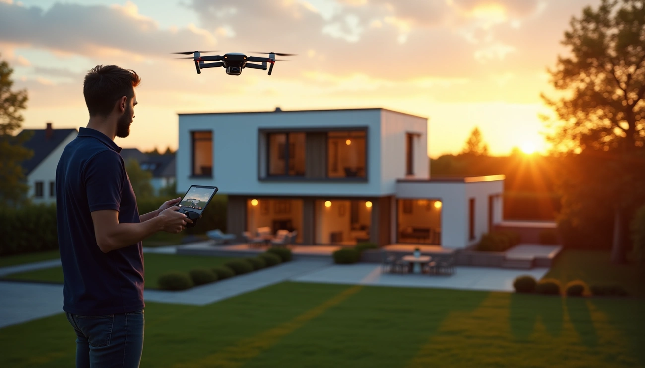
The playing field of real estate marketing has changed irrevocably. Up to 83% real estate agents are now using aerial videos in their property presentations – and for good reason. 🏠
The numbers speak for themselves: over 400 professional photographers and 10,000 satisfied customers can't be wrong. Drone photography has become mainstream, and customer satisfaction speaks for itself – a whopping 961% of customers recommend their chosen photographer, and the average rating for services reaches 4.7/5.
Previously, aerial photography required a helicopter or airplane, which made it a luxury product. Drone technology has changed everything. Now, aerial photography of your property in Tampere starts at just 70 euros, while a more extensive photography session ranges from 120 to 550 euros, depending on the size of the property. A five-minute promotional video can be done for around 200 euros. These prices open up the possibilities of aerial photography to ordinary property owners as well.
But how do you find the right professional photographer for your property? In this article, we'll walk you through the options and show you how you can choose the best photographer quickly and efficiently - without guesswork or time-consuming comparisons.
Read more: Drone photography and drone images >>
Read: Visu24 customer experiences:
Professional cooperation with Visu24: Photorealistic 3D images bring architecture to life >>
Visu24 implemented 3D modeling and video adaptation for Energiequelle's wind power projects for the EIA procedure and landscape impact assessment >>
What does drone photography of a property mean?
The real estate industry is undergoing a visual revolution. Drone photography is not just a technical term – it is a whole new way of seeing and displaying real estate. It involves taking aerial photos and videos using unmanned aerial vehicles equipped with with high-quality camerasThis technology has turned the way agents, developers and resorts present their properties on their heads.
The basic idea of aerial photography
Real estate marketers stuck in traditional photography are inevitably left behind. The core idea of drone photography is simple yet revolutionary: to show a property in a way that was previously impossible.
Drones – that miniature helicopter – open the doors to a completely new kind of view. They fly high, photographing subjects, reaching areas and perspectives that traditional photography methods can never reach.
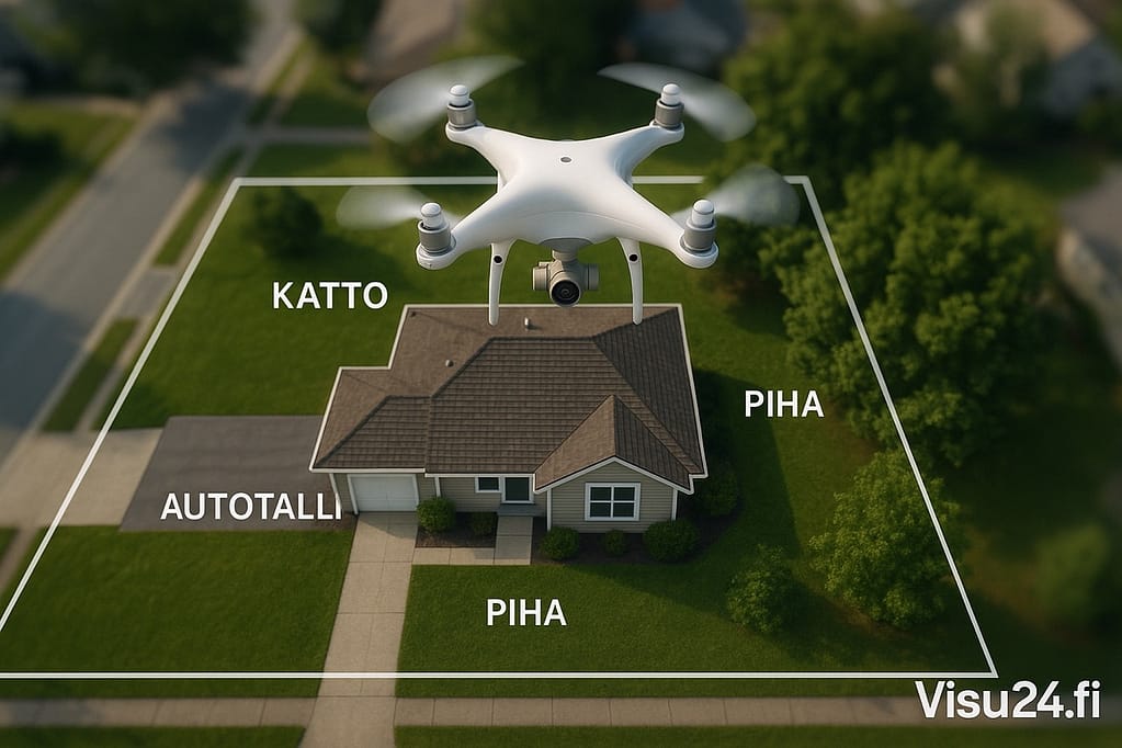
Photos taken from the ground only tell part of the story. Drone footage, however, reveals:
- Roof lines and condition
- Actual dimensions of yard areas
- The boundaries and overall size of the plot
- Environmental and neighborhood context
This is especially valuable for larger properties or sites located near bodies of water or parks – features that ground-level imagery simply cannot capture.
The basic idea behind drone photography is straightforward:
- Create visually captivating images that instantly stand out from the competition
- Reveals details and proportions of the subject from a bird's eye view
- Shows the best aspects of the property and its environmental relationship
- Gives buyers a true sense of the location and surroundings
In practice, drones achieve angles that traditional methods simply cannot achieve. With professional post-processing, every image and video increases the value of the subject and leaves a lasting impression on the viewer.
As technology has developed, it has also become available FPV drones (First Person View), which allows for seamless exterior and interior shots. These fast-paced videos take the viewer on a virtual tour of a property like never before.
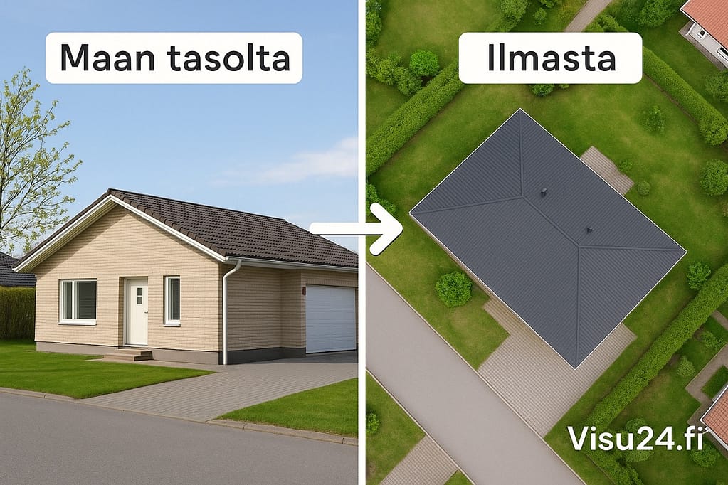
Difference from traditional photography
Can a photo taken from the ground ever compete with an aerial photo? The answer is clear.
Real estate marketing has long relied on traditional photography and static video. However, drone technology has brought a completely new visual language into the game. The key difference lies in perspective and coverage.
First, traditional photographs only capture what can be seen from ground level. These images do not do justice to larger plots or landscapes, which can make up a significant portion of a property’s value. A drone’s bird’s-eye view, on the other hand, provides a holistic view of the property and its surroundings.
Secondly, only aerial photography can truly showcase the relationship between the property and the landscape. With a drone, an agent can show the house's placement in its surroundings in a way that brings out the property's full potential.
Drone photography also brings an element of dynamism. A video that starts in the air and slowly descends towards the property creates a dramatic and professional impression. This allows you to highlight the special features of the property:
Luxury properties with swimming pools, terraces and landscaped gardens benefit greatly from aerial photography. These features stand out in a way that is impossible to achieve from ground level. Buyers can clearly see how different areas and spaces are positioned in relation to each other.
Drone photography also offers clear advantages in practical inspections. Inspections of difficult-to-reach areas such as roofs, eaves and chimneys are significantly easier. Drones record visual documentation that can be returned to later for comparison.
However, it should be remembered that amateur drone flying can lead to unexpected accidents or dangerous situations. Therefore, we always recommend choosing a professional photographer, whether it is a drone photography in Helsinki, Tampere, Turku or anywhere else in Finland.
Station Drawing – Price, Content and Instructions: Everything You Need to Know >>
The best free floor plan and floor plan drawing programs >>
When is drone photography worth it?
Standing out in the real estate market is harder than ever. The rise of drone technology has made aerial photography accessible to even the average property owner. But when should you really invest in drone photography? Let’s take a closer look at when aerial imagery can bring real value.
Selling or renting a home – aerial photos are a selling point
The harsh truth about real estate: competition is fierce and first impressions matter. Studies reveal a startling fact – houses that use aerial photos in their marketing sell even more. 68% faster than items presented with traditional images. Video content, on the other hand, increases the number of inquiries by a huge amount 403%These aren't just numbers – they're proof that a bird's-eye view sells.
The value of aerial photographs is particularly emphasized:
- In the case of large properties, when the dimensions of the plot do not extend from ground level
- Near bodies of water or parks, where the environment acts as a trump card
- When selling plots of land, the buyer needs to understand the boundaries and possible uses of the land.
In addition to real estate, boat sellers and renters benefit from dramatic aerial photos – during the summer season, impressive aerial photos in boat listings stand out from the competition.
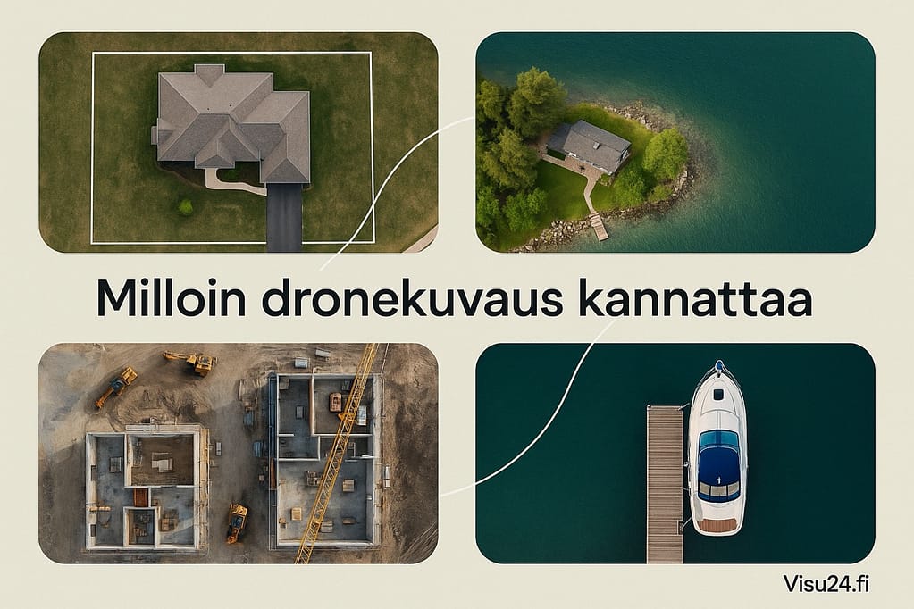
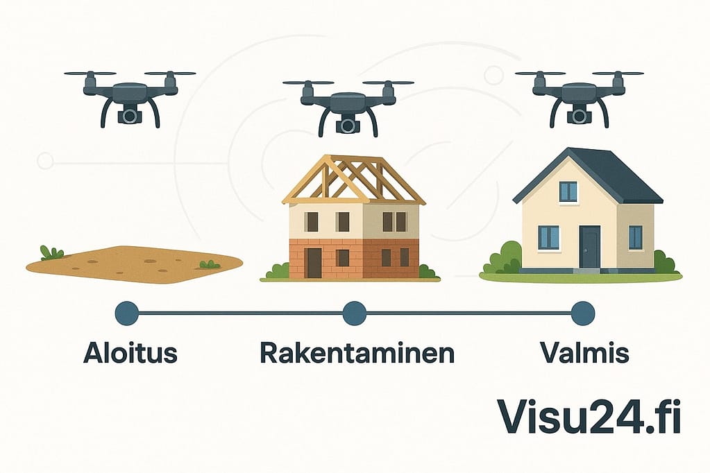
Construction project documentation – see the whole picture at a glance
Drone documentation in the construction industry has revolutionized project monitoring. No more guesswork or ambiguity – now project managers can see the entire site situation at a glance.
Drone photography allows you to:
- A reliable, visual timeline of the different stages of the building
- A detailed view of material stocks and construction site organization
- Early intervention in problems before they escalate into crises
Images don’t just document – they tell a story. This visual story can be used in investor communications, site logistics planning and future marketing. In the world of construction, a picture really is worth a thousand words – especially when taken from a height of 50 meters.
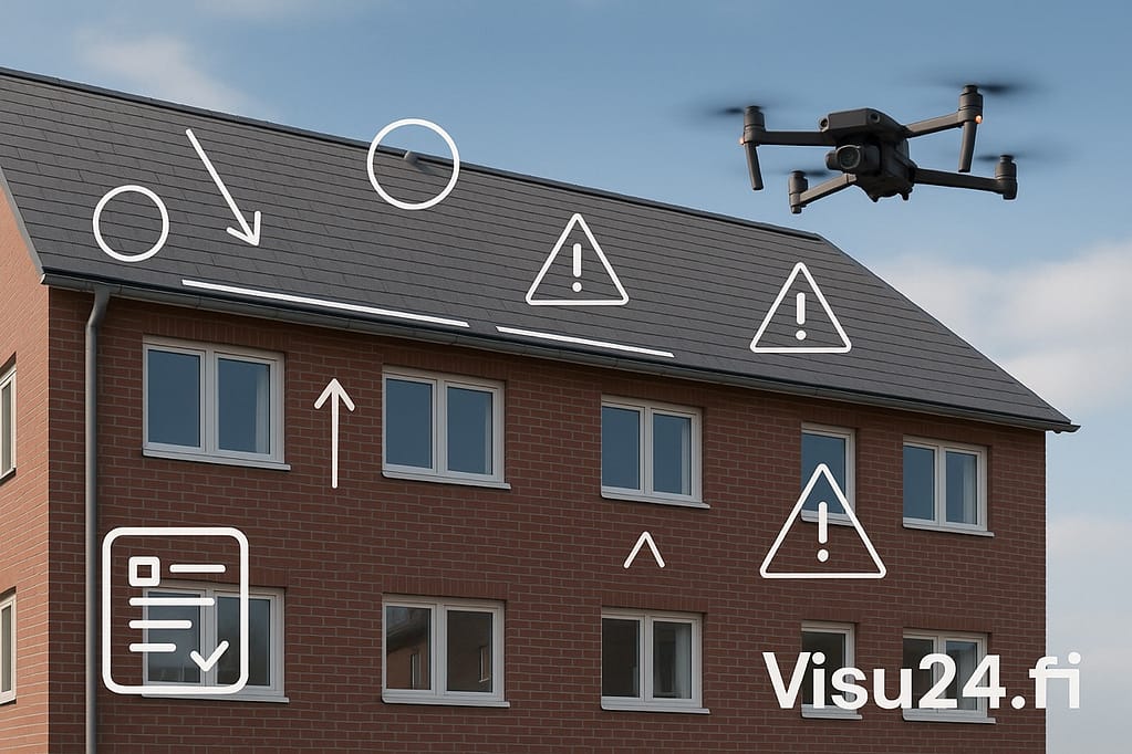
Inspection and maintenance operation – safely and cost-effectively
Imagine a 3-story house that needs a roof inspection. The traditional option: rent a lift, hire a person, book a day. The same inspection with a drone: 15 minutes, one person, a fraction of the cost.
Drone photography especially excels in inspecting hard-to-reach areas:
- The condition of roofs, chimneys and eaves is revealed without climbing a ladder
- Facade damage is clearly visible in detail
- The functionality of solar panels can be checked with a thermal camera
- Assessing the condition of power lines can be done safely and remotely
The cost impact is significant. Depending on the size of the property, the cost of a drone survey and inspection report is usually less than a thousand euros – a fraction of the cost of traditional inspection methods.
Specially designed indoor drones bring the benefits of technology to confined spaces: tanks, boilers, tunnels and pipelines. In these spaces, drone photography can even replace risky inspections performed by humans.
The value of drones in property maintenance is especially emphasized after winter, when possible roof damage caused by snow loads needs to be checked. The images also serve as a reference point in the future – changes in the condition of the structure are easily revealed when reference material is available.
However, it is important to remember that while drone photography is an excellent tool, it does not completely replace a thorough condition survey. At best, it complements and supports other survey methods, ensuring that nothing important is missed.
Discover: Floor plans help in the construction and real estate industry! >>
3D modeling – what are its benefits in the construction industry? >>
The benefits of drone photography in real estate marketing
Selling real estate is not what it was even five years ago. Drone photography has become a necessity in an industry where first impressions matter. Aerial photos and videos are not just a marketing tool – they are a game-changing force that both differentiates sellers from their competitors and attracts buyers with unprecedented power.
Visual impact
In real estate, the truth is simple: you only have seconds to convince a potential buyer. Aerial photos attract more views, more inquiries, and lead to faster sales.
The superiority of drone imagery is based on three key factors:
- The power of a bird's eye view: The perspective provided by a drone presents a subject from an angle that traditional ground-level images can never reach.
- Technical superiority: Modern drone technology produces amazingly detailed, high-resolution images that will give you a wow reaction.
- Cinematic movements: A slow-motion video that gradually reveals the property creates a professional and immersive viewing experience
The numbers speak for themselves. Properties with aerial photos sell. 68% faster than traditional image-based targets. Even more startling: video-based ads are generating up to 403% more contacts.
“FPV drone photography takes this even further,” says a leading real estate photographer from Helsinki. “With these First Person View drones, we can create seamless transitions from outdoors directly to indoors, creating a completely new, experiential tour of the property.”
Professional post-processing elevates the impact of every image and video to a new level. When the lighting, colors, and composition are perfect, every strength of a property stands out in a way that leaves a lasting impression.
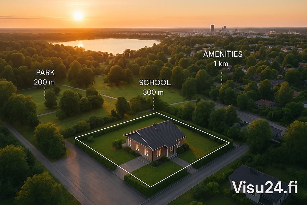
Perceiving the environment
Traditional land plans never reveal the whole truth. They do not tell the true dimensions of a plot, do not show where the boundaries are, and do not illustrate the relationship of the property to its surroundings.
Aerial photography fixes this shortcoming in an instant:
- The boundaries and shapes of the plot become clearly visible, eliminating uncertainties
- Distances to the nearest services, schools and parks are clearly outlined
- The location of landmarks in relation to the property is drawn in a clear map-like image
This is particularly valuable when marketing large plots of land, farms and seaside properties, where the surroundings and scenery are a significant part of the property's value. Aerial photography reveals features that are simply impossible to showcase using traditional methods.
Buyers no longer just look at a property – they experience it as a whole, part of their environment. This emotional connection can be the very thing that turns interest into a purchase decision.
Stand out from the competition
In a market where properties compete for attention, drone photography is a broker’s secret weapon. A broker who invests in high-quality aerial photos and videos sends a clear message: “I’m using the best tools possible to get you the best possible result.”
Think about it from a practical perspective. Instead of organizing countless viewings of properties that only a few of them are of serious interest to buyers, you can eliminate unnecessary visits. Potential buyers can first get to know the property via drone video and make an informed decision about whether they want to see the property live.
Drone videos are a goldmine on social media. They garner significantly more exposure, shareability, and engagement than traditional real estate photos. Not only does the property reach more viewers – it reaches a higher quality audience that is already interested.
Real estate agents in Turku, Jyväskylä and elsewhere in Finland have noticed an immediate impact: more inquiries, longer viewing times and ultimately more offers. Although drone photography initially appears to be an additional cost, it pays for itself many times over.
“Buyers are no longer willing to guess,” says an experienced real estate agent from Tampere. “They want to see everything – the boundaries of the plot, the neighborhood, the distances to services – even before they contact us. Drone photography offers exactly this transparency.”
Best of all, this transparency builds trust between the broker and potential buyers before the first meeting, streamlining the sales process and significantly improving the experience for everyone involved.
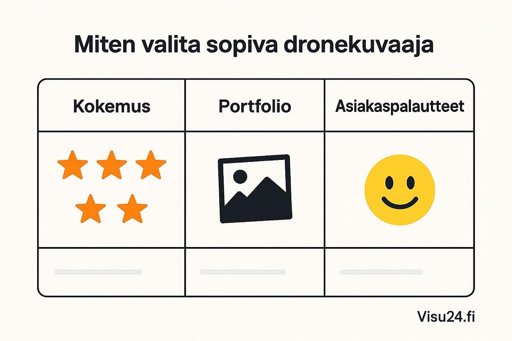
How to choose the right drone photographer?
When it comes to maximizing the value of your property, choosing the right drone photographer is not a secondary decision. It is a crucial step that can significantly increase the attractiveness of your property. But how do you distinguish a true professional from a mere amateur with flying skills? There are hundreds of drone photographers operating in Finland – from small entrepreneurs to larger companies – but not all of them produce the same quality.
Experience speaks for itself 🧠
The first thing you should pay attention to is not price, but experience. Years in the industry alone don’t tell the whole story – actual flying hours are a much more telling metric. Experienced professional photographers have flown for over 1,000 hours and shot over 210,000 meters from the air.
Such an experience is immediately visible:
- The drone is controlled precisely even in challenging weather conditions
- Angles are instinctively chosen to benefit your property
- Common mistakes that ruin shots can be avoided
Always check these basics:
- ✅ Permits and certificates issued by Traficom
- ✅ Properly registered drone (mandatory for devices over 250g)
- ✅ Valid liability insurance
- ✅ A1/A2/A3 category long-range flight licenses
A professional filming situation reveals a lot: a certified cameraman often has clear roles – one acts as a remote operator, the other as a spotter to ensure safety. This is not just bureaucracy, but a sign that occupational safety is taken seriously.
The portfolio tells the truth 📸
“A picture is worth a thousand words” is especially true in the world of drone photography. A portfolio is the best way to assess whether a photographer is the right choice for your project.
When examining a photographer's portfolio, pay attention to these:
- Technical quality: sharpness, lighting control, color balance
- How the properties are presented: do the images highlight the best aspects of the property?
- Post-processing level: professional, but not over the top
- Versatility: do you have experience with different types of properties?
Versatility is a photographer's ability to adapt. For example, the founder of Dronekon Oy shoots on land, at sea, and on the ski slope - this flexibility is valuable when the needs of your project change.
Don’t forget your editing skills. Shooting is just the tip of the iceberg – color grading and editing often take more time and require a completely different level of expertise. A good photographer can also bring out the strengths of your property in post-production.
What do customers really say? 💬
Customer satisfaction is the best indicator of a photographer's professionalism. In Finland, customer satisfaction is high for several drone photography services – one of the most popular services in the industry reports that over 961% of customers recommend their chosen photographer.
When examining feedback, look for these signs:
- Overall ratings (aim for at least 4.7/5)
- Comments on schedule adherence
- Mentions about the quality of communication
- Customer satisfaction with the end result
"Thank you! The service via text, phone and live was professional, polite and fast. We are very satisfied with the service and the price-quality ratio is very good!" - comments like these reveal a professional who understands the importance of both technical expertise and customer service.
Also pay attention to the photographer's client portfolio. References such as Geonex Oy, TPH Saneeraus Oy and the City of Tampere speak of the ability to serve demanding clients. The feedback from the communications manager of Laukaa Municipality, "Dronekon did the drone photography with high-quality equipment, with a competent approach and with the utmost customer service," speaks of the level of service.
One more practical tip: check the photographer’s turnaround time. A professional will typically deliver the finished materials within two days of the shoot. This allows for quick progress in marketing – no waiting weeks for the final result.
Read more: Floor plans, what are they and why are they important? >>
Discover: 3D visualizations for new developments. Discover our selection now! >>
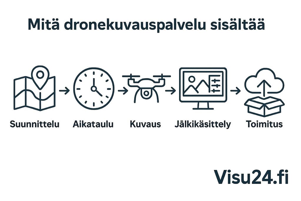
What does the drone photography service include?
Drone photography is not just about flying and pressing a button. Professional services involve a complete production process, where every step is honed to perfection. But what are you really paying for when you order drone photography for your property?
Filming planning and scheduling – the foundation for success
A professional doesn't arrive and start filming right away. Real drone photography starts long before the drone takes off.
During the planning phase, the photographer will go through:
- Special features of the destination and best angles
- Safe take-off and landing locations for drones
- For longer descriptions of the battery replacement plan
- Flight altitudes and routes for best results
- Weather precautions and contingency plans (wind and rain can ruin the shoot)
“If you need drone photography, don’t choose the cheapest option – choose a professional who knows both the technology and the legislation,” say the professionals at VideoGuru. This says it all.
Timing is part of the art. Morning sun creates a different atmosphere than afternoon light, and a professional can recommend the best time of day to photograph your property. The length of shadows, the amount of light, and the direction – these are not coincidences, but careful planning.
Delivery of images and videos – quickly and reliably
After the shooting, the work phase begins, which separates an amateur from a professional. When you deliver the material, you can see concretely what you get for your money.
Professional photographers typically provide processed materials 1-3 business days For example, freelancer Julius Jansson describes his process clearly: “I carry out the shoot at the agreed time, edit the images and send them to you as full-quality jpg files via the WeTransfer service.”
So what do you get in your hand? Usually the delivery package includes:
- 10-15 carefully edited real estate photos
- A one-minute video summary (if ordered)
- Materials in high-quality format (4K resolution for videos)
Elias Kalliola's service description sums it up: "The service includes photography at an agreed location, professional image processing, and delivery of finished materials via a download link." Clear, straightforward, and efficient.
Post-processing and permissions – the difference is in the details
Post-processing isn’t just an addition to drone photography – it’s its soul. Professionals often spend more time editing their images than they do shooting them. This is the stage where mediocre footage turns into amazing footage.
VideoGuru's professionals reveal what happens behind the scenes: "We compile, cut and edit the videos and do all the necessary and desired things in the post-processing phase, such as color grading, adding music and texts."
What does this mean for marketing your property?
- Color optimization brings out the best in your property
- Balancing lighting corrects the grayness of a cloudy day
- Sharpness adjustment makes every detail visible
- Removing distracting elements (like random cars) from images
- Background music and rhythm suitable for videos
The usage rights are clear – you get full rights to use the images in your marketing, social media and all your communications. The photographer usually keeps the materials in their own archive for about 12 months, so you can request them again if necessary.
A comprehensive drone photography service is like a work of art, where every brushstroke is considered. A professional photographer takes care of all the flight permits, safety and technical details. All you have to do is take advantage of the stunning images and videos that showcase your property in the best possible light.
Discover: 3D images of new properties 24/7 >>
Read more: 360 photos for pre-marketing and sales campaigns from Visu24 >>
The price of drone photography and the factors that affect it
Pricing for drone photography isn’t rocket science, but there are a number of factors that go into it. Before you decide to commission aerial photography, it’s a good idea to understand what goes into your final price – and why choosing the cheapest service could be a costly mistake.
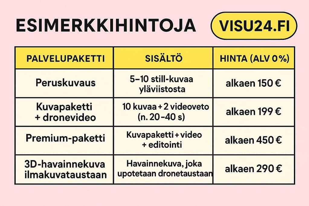
In Finland, the price of drone photography typically ranges between 150–500 euros per photography session or 70–150 euros per hour. For more demanding projects, the hourly price can rise to 200 euros. But what causes these differences? Let's take a closer look.
Size and geographical location of the site
The size of the property directly affects the price of drone photography. A simple equation: larger property = more to photograph = more time and resources = higher price.
The impact of location on pricing is clearly visible:
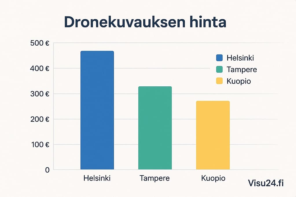
- Prices in Helsinki and Tampere average around 34 euros per image.
- In the provinces, you can typically get by with 23 euros per photo.
- The starting price for aerial photography in Tampere is only 70 euros (VAT 0%)
The importance of geography is emphasized when the photographer has to travel. “Travel time 1.5–2 hours from Rovaniemi to Pello” increases the price considerably – no one drives hundreds of kilometers for free. Special destinations have special prices: shooting an island in Kuopio can easily cost 1240 euros.
Image quantity, quality and post-processing 📸
Professional photography equipment isn’t cheap – modern drone equipment costs between €2,000 and €5,000 and needs to be replaced every 3-4 years. This investment is inevitably reflected in the pricing.
The total cost of the shoot is significantly affected by:
- Battery life (longer shooting = more battery changes)
- Number of images (additional images are typically charged at €25–50 + VAT per image)
- Scope of post-processing
Few clients understand that post-production often takes as much time as the shooting itself. An hour's worth of footage requires an hour of editing. The cameraman takes hundreds of frames, from which only the best are selected for final delivery.
Special requirements increase the price significantly
Flying in restricted airspace isn't free – special permits can cost hundreds of euros per flight. FPV drone photography, which allows for fast-paced indoor and outdoor photography, also increases the price.
The cost structure of a professional photographer is complex:
- Two different insurance policies (liability insurance + equipment insurance)
- Ongoing maintenance and spare parts costs (memory cards, filters)
- Editing software licenses
Special projects, such as documenting the installation of roof elements or photographing a large construction site, are priced individually – prices for such projects start at 940 euros and can exceed 1000 euros.
The final price also depends on the service model. If the same person handles both filming and editing, the price is typically higher than for companies that outsource post-production.
The price of drone photography is therefore not determined by flight time alone, but rather by the total package: planning, photography, post-processing and delivery. A carefully selected professional photographer may not be the cheapest, but will bring out the best in your property in a way that pays for itself.
Permits, safety and regulations – What drone photographers need to know
The exciting possibilities of drone photography are often overshadowed by the lack of clarity about the rules. Although a drone that takes pictures opens up new views of a property, flying it requires more than just piloting skills. It is important to know the rules – whether you are the photographer or the client who hires the photographer.
The EU Drone Act 2020 significantly changed the playing field in Finland as well. Previously confusing practices were unified, but at the same time, many were surprised by the new requirements.
Where you can fly a drone – and where you can’t 🚫
Flying a drone requires careful background work. The route plan is not just a matter of efficiency, but also a safety factor.
There are permanent no-fly zones in Finland:
- Nuclear power plants and their surroundings
- Sites important to national defense
- Central government buildings
Near airports have their own restrictions:
- Flying in the innermost zone is prohibited without separate permission from air traffic control.
- In the middle zone, you may only fly within 50 m of an obstacle and no more than 15 m above it.
- In the outer zone, the maximum flight altitude is 50 meters.
In addition, temporary restrictions must be taken into account - large public events and military exercises constantly change the permitted areas. In 2021, Traficom also established special UAS zones where drone use is either completely prohibited or separately permitted.
Drone photographers must check the restrictions for each flight in advance on Traficom's droneinfo.fi website. It is also worth noting that the maximum height of a drone is generally 120 meters - climbing higher requires special permits.
On the limits of privacy – what can be photographed?
Aerial photography does not take away people's right to privacy. This is a line that every drone photographer should be aware of.
The provisions on surreptitious surveillance also apply to drone photography:
- Photography is permitted in public places.
- Photographing people under house arrest is prohibited.
- Simply taking pictures is enough to commit a crime – publishing the pictures is not necessary
"Drones make filming easy, but at the same time they make it difficult to understand privacy protection. It is the photographer's responsibility to ensure that domestic peace is not violated," says an expert specializing in drone legislation.
If you suspect that you have been the target of unauthorized drone filming, contact the emergency services immediately. Surveillance can result in a fine or up to a year in prison.
Professional photographers are a step ahead here too – they usually inform the residents of the area they are filming in advance, especially if the photos are of facades and windows. This avoids unnecessary suspicion and worries.
Registration and insurance – essential paperwork
EU legislation has brought stricter regulations to drone operations. Obligations that previously only applied to professionals now extend to many hobbyists:
- All users of drones weighing more than 250 g must register in the drone operator register.
- Registration fees range from €30-100 depending on the duration
- Online theory test for pilots
When it comes to insurance, the boundaries are clear – the EU requires insurance for all drones weighing over 20 kg. Insurance is not mandatory for smaller devices, but a professional photographer won't fly without it.
Liability insurance covers damage caused by a drone, but not damage to the drone itself. It is also important to note that damage caused by illegal flight will not be covered – insurance companies do not cover damage caused by illegal operations.
When choosing a drone photographer, checking insurance is a basic consideration – a professional always has both registrations and liability insurance in place. This way, the client can breathe a sigh of relief and focus only on the content of the photos, not their legality.
Discover: 3D floor plans and drawings from Visu24 >>
Read more: How to speed up the sale of your new property with new property visuals >>
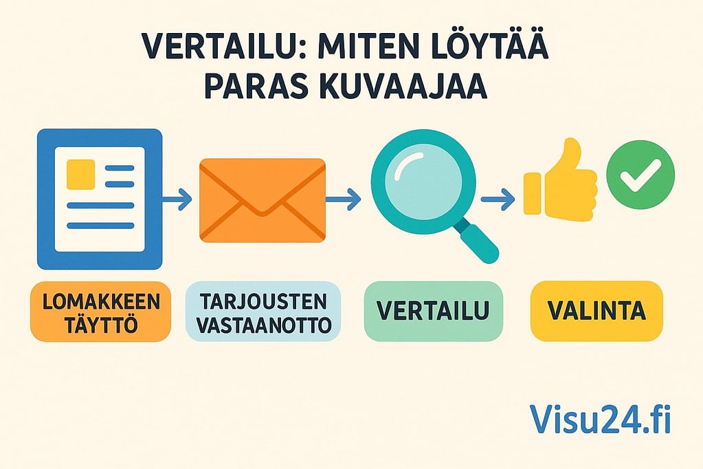
Comparison: How to find the best photographer easily?
Your property deserves the best possible aerial photography. But how do you find the right professional for your needs among dozens of potential photographers? Fortunately, there are solutions for this.
Competitive bidding services: the fastest route to comparison
There are several services in Finland that make finding a drone photographer easy. Valokuvaajat.fi stands out clearly from these – through it you can bid on drone photography for free, and customer satisfaction is a testament to the functionality of the service. As many as 96% customers recommend the photographer they have chosen.
The bidding process typically proceeds like this:
- You state your needs in a clear form
- The service connects you with suitable professionals
- Receive comparable offers directly to your email
- You choose the option that suits your needs and budget.
Ilmakuvaajat.com, on the other hand, brings together professionals who specialize in aerial photography and offers local information about available services.
Competitive bidding services save you time and effort as you don't have to search for and contact each photographer individually. At the same time, you get a clear idea of the prevailing price level.
Local highlights: city-specific offerings 🔍
It makes sense to consider the location when choosing a photographer – a local professional knows the area and travel costs will remain reasonable.
Helsinki and the capital region: There is plenty of choice in the Helsinki metropolitan area. Propeller Helsinki offers aerial photography packages starting at €150 + VAT, including one photo shoot with travel expenses. The price level is slightly higher than elsewhere in Finland, but the Helsinki metropolitan area also has top professionals whose portfolios will convince even the most demanding client.
Tampere and surrounding areas: In Tampere, prices for aerial photography start at 70 euros (VAT 0%), which makes drone photography a particularly attractive option. Valokuvaajat.fi lists several options in the Tampere area, such as Dalofin Media, Kaisa Virkkala Fotografia and Kuvalähte. In Pirkanmaa, competition between professionals keeps the price level reasonable.
Turku region: There is also a range of services in Turku. Raeven offers full-service drone photography starting at €200 + VAT, with delivery including both photos and videos. Karlex, on the other hand, offers aerial photography services at prices of €250-370 depending on the scope of the service.
Quality criteria: what to ask before ordering ✅
Choosing a drone photographer is like recruiting any professional – asking the right questions will reveal the best ones. Make sure to at least:
- Permits and registration: "Are you a registered drone operator? Do you have A1, A2 and A3 qualifications and liability insurance?" A professional will have these in place, without any explanation.
- Stock: “What equipment do you shoot with?” Top photographers use quality equipment like the DJI Mavic 3 Enterprise E, whose 20 megapixel Hasselbad camera produces stunningly sharp images.
- Schedule and delivery: "When will I get the finished materials?" Professionals typically deliver the processed materials within 1-3 days of the shoot - no waiting for weeks.
- Pricing transparency: “What exactly does the price include? Does it include image processing, travel expenses, video editing, or other additional services?”
- Weather reservation: “What if it rains on the day of the shoot?” Make sure the contract has clear terms for changes caused by weather.
Professionals usually hold a planning meeting before the shoot, where they go over the location, angles, and schedule in detail. This is a sign of experience and customer focus.
As Braleva's technical management has proven in practice, high-quality drone photography makes inspections easier, saves time and money, and increases occupational safety. That's why it's worth taking a moment to choose a photographer - the end result will be reflected in the value and attractiveness of your property.
Discover: How 3D modeling makes it easier to sell your new property >>
Read more: Virtual tours make it easier for your customer to make a purchasing decision >>
Final words
The impact of drone photography on real estate marketing is undeniable. As we have seen, properties with aerial photos sell even 68% faster and generate 403% more queriesThese aren’t just numbers – they’re proof that a shift in perspective transforms the entire buyer experience.
But the benefits of drone photography extend far beyond sales:
- 🏗️ Construction project monitoring becomes transparent and easily documented
- 🏠 Property condition inspections can be carried out safely and cost-effectively
- 🔍 Hard-to-reach areas such as roofs and facades are inspected without cranes or scaffolding
When looking for the right drone photographer for your property, remember that professionalism is reflected in experience, convincing references and satisfied customers. In addition to flying skills, a good photographer masters the post-processing of the material and is familiar with the regulations in the field. Knowing these regulations is not just a formality – it is a sign of professionalism and safety.
The price range of 150-500 euros makes drone photography an investment that pays for itself many times over. This amount usually includes the entire package from design to delivery – without hidden costs or surprises.
A bird’s eye view reveals aspects of your property that you never see from the ground. It tells a story that extends from the square footage to the neighborhood and surrounding opportunities. This holistic view has made drone photography the standard for real estate marketing.
Your property deserves to be seen in the best possible light. So choose a photographer who understands both the technical requirements and the unique strengths of your property. The results don’t just speak for themselves – they scream.
Order drone photography now
Through Visu24 you can get drone photography cheaply and quickly – whether you are in Helsinki, Tampere, Oulu or anywhere else in Finland. Through us you compete with several photographers with one request for quotation and easily find a professional who meets your needs. Our network of photographers is the most comprehensive in Finland, so you can trust that you will receive high-quality service quickly and effortlessly.
Read more:
Read Visu24 customer experiences >>
See Visu24's references and work samples >>
FAQs
Q1. Why is drone photography useful for selling real estate? Drone photography speeds up the sale of a property by up to 68% and increases the number of inquiries by 403%. Aerial photos provide a comprehensive view of the property, its surroundings and dimensions, which helps buyers better understand the overall picture of the property.
Q2. How much does drone photography cost in Finland? The price of drone photography in Finland typically varies between 150 and 500 euros per photography session. The price is affected by the size of the object, location, number and quality of images, and any special requirements.
Q3. What permits are needed for drone photography? Users of drones weighing more than 250 grams must register with the drone operator register. In addition, a network theory test and possibly special permits for flying in certain areas are required. Privacy rules must also be observed.
Q4. How do I choose the best drone photographer? Choose a photographer with experience, good references and positive customer feedback. Check the photographer's qualifications, the quality of their equipment and delivery times. You can use competitive bidding services or look for local options in Helsinki, Tampere or Turku, for example.
Q5. What other than sales can drone photography be used for in the real estate industry? Drone photography is used to document construction projects, map property maintenance needs, and inspect hard-to-reach areas such as roofs and facades. It is a safe and cost-effective way to perform a variety of property-related tasks.