1. Everything you need to know about a site plan
The article answers the following questions:
What is a station plan?
What is a site plan needed for?
What is the difference between a site plan and a site plan?
Why is a site plan important in the building permit process?
Can a site plan be electronic?
The site plan is a key part of the building permit process, with the help of which the building inspector assesses that the planned construction complies with the plan, building regulations and land use decisions. The site plan shows the boundaries of the plot, the location of the buildings, the height ratios and other key information. It serves as both a technical drawing and a visual representation that helps authorities and stakeholders understand the plan as a whole.
In practice, a site plan is part of the main drawings attached to a building permit application. It is sometimes also called a site plan, but the official name is a site plan. A site plan generally uses a scale of 1:500 or 1:200, depending on the size of the plot and the complexity of the building.
The importance of a site plan is particularly emphasized in new construction projects and when significant changes are made to the conditions of the construction site. A building permit is usually not granted without a site plan, as the authorities need the plan to ensure the suitability of the construction for the plot and the environment.
The best free floor plan and floor plan drawing programs >>
Discover: Floor plans help in the construction and real estate industry! >>

Illustration: a plan image showing the plot boundaries, building and plan markings.
2. Content and requirements of a station drawing – What a station drawing contains and why the content is important
A site plan is an official document whose content determines its acceptability in the building permit process. Building inspection authorities use the site plan to check that the planned construction complies with the plan, the construction sequence and the specific requirements of the plot. The content of the site plan therefore plays a decisive role in the progress of the construction project.
A station drawing contains several mandatory pieces of information that must be presented with a certain level of accuracy and format. These include, for example:
- plot boundaries and dimensions
- placement of buildings on the plot
- distance of buildings from boundaries and from each other
- elevation data and contour lines
- north arrow to indicate direction
- vehicle and pedestrian traffic arrangements
- plan markings and plan regulations
- existing and demolished structures
This information ensures that the construction will not cause a nuisance to the neighborhood, violate the zoning plan, or prevent the building rights of others. If the site plan is missing the required information, the building permit application may be returned for completion, which will delay the entire project.
The site plan should be prepared clearly and comprehensibly so that the authorities can assess the plan without further clarification. A high-quality site plan reduces the risk of rejection and speeds up the permit process.
The content of a station drawing is generally presented in the following scales:
- 1:500 – the most common scale in topographic maps
- 1:200 – used on smaller plots and in more detailed presentations
- 1:1000 – for presenting large areas and extensive entities
The content of the station drawing is guided by, among other things: RakMK A2 and Ministry of the Environment instructionsThese requirements define what information and markings must be included in the drawing.
3D modeling – what are its benefits in the construction industry? >>
Read more: Floor plans, what are they and why are they important? >>
3. Stationary drawing scale – What is the correct scale for a stationary drawing and why is it important?
A site plan is always drawn up to a certain scale so that all buildings, boundaries and yard arrangements are shown in the correct proportion to the plot and the environment. The scale affects the readability of the site plan and how accurately different details can be presented. Building control requires a scale that corresponds to the size of the plot and the extent of the planned construction.
The most common topographic scales:
- 1:500 – usually used in single-family homes and single-family home site plans
- 1:200 – suitable for smaller plots and more detailed plans
- 1:1000 – suitable for large areas or extensive plans
Choosing the right scale is important because a scale that is too small can make the drawing unclear, and a scale that is too large can leave out important details. Building control may require a more precise scale, for example in a densely built-up area where the distances between buildings are critical.
The scale of a site plan should always be chosen based on the nature of the project and the size of the construction site. At the same time, it must be ensured that all necessary markings and information fit into the drawing without becoming unclear.
Factors influencing the choice of scale:
- plot size
- number and location of buildings
- level of detail in the design requirements
- building control requirements
- environmental characteristics
Discover: 3D visualizations for new developments. Discover our selection now! >>
Read more: Drone photography and drone images >>
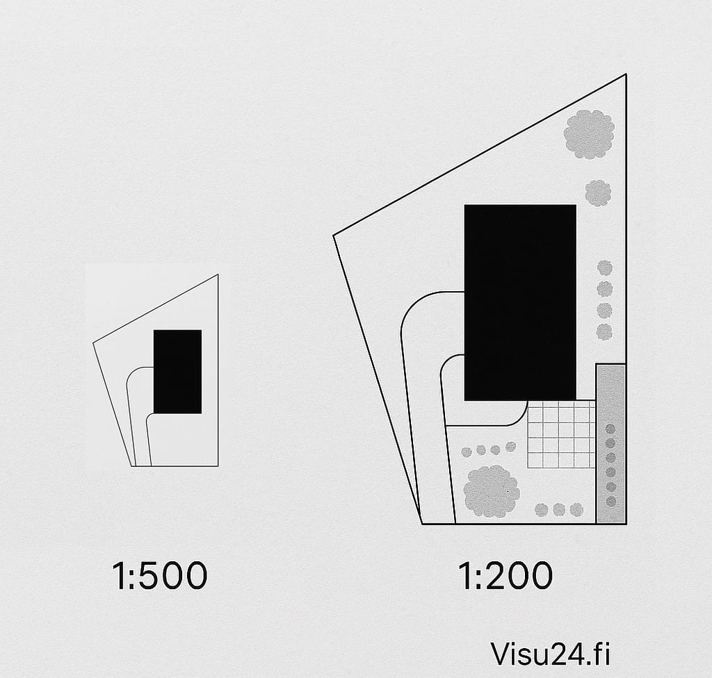
Illustration: two parallel topographic drawings at different scales, showing the difference in the accuracy of detail.
4. Stationary drawing markings – What do the markings on a stationary drawing mean and why are they important?
Site plan markings are an essential part of the content of a drawing and directly affect its acceptability in the building permit process. Each marking has its own purpose, and they help authorities, designers and contractors read the drawing correctly. Properly prepared site plan markings help ensure that the plan meets all zoning regulations, distance requirements and technical requirements.
The main location drawing markings:
- Plot boundaries: the plot boundaries and their dimensions must be clearly shown
- Location of buildings: dimensions of the external walls of buildings and distances to the boundaries
- North Arrow: indicates the direction of the wind, a mandatory part of the map
- Elevation stations: markings of building corner points and plot elevation readings
- Vehicle and pedestrian routes: driveways, emergency routes and pedestrian connections
- Plan markings and plan regulations: planning conditions related to the plot, such as intended use and building rights
- Building fire classification and locations of emergency shelters: markings in accordance with safety regulations
These markings ensure that the site plan contains all the essential information for the assessment of the construction project. If the markings are missing or unclear, the building inspectorate may reject the application or request additional clarification, which will delay the project.
How do you ensure the accuracy of the markings on the site plan?
- make sure that you have an up-to-date plan and base map
- use a professional with experience in site plans
- check the municipality or city's specific instructions for submitting entries
Discover: 3D images of new properties 24/7 >>
Read more: 360 photos for pre-marketing and sales campaigns from Visu24 >>

Illustration: an example drawing of a station plan, where all markings are named and explained.
5. Site plan yourself – Can you do the site plan yourself or is it worth ordering it from a professional?
A site plan made by yourself may sound like an attractive option, especially for smaller construction projects. From a legal perspective, anyone can prepare a site plan, but in practice, municipalities and building inspectorates set requirements for the quality and content of the plan. This means that even if a site plan is possible, its acceptability may be problematic without sufficient expertise and the right tools.
Station drawing yourself – what are the challenges?
- Qualification: Many municipalities have requirements regarding the qualifications of the draftsman, especially regarding knowledge of planning requirements and building regulations.
- Technical requirements: The site plan must contain all mandatory markings and information at the correct scale.
- Software requirement: A topographic drawing program, such as AutoCAD, requires expertise and a license.
- Acceptability: A self-made site plan can delay the building permit process if the plan does not meet the requirements.
While the site plan itself can save costs in the initial stages, potential corrections, additional investigations and rejections can increase costs and slow down the project in the long run. That is why many builders end up commissioning a site plan from a professional who has the experience, the right tools and an understanding of regulatory requirements.
Do-it-yourself or professional layout drawing – comparison:
- Self-made layout:
- requires technical expertise
- Risk of incomplete labeling
- may delay the permit process
- A professional site plan:
- contains all required markings
- speed up permit processing
- reduces the risk of errors
Discover: 3D floor plans and drawings from Visu24 >>
Read more: How to speed up the sale of your new property with new property visuals >>

Illustration: a self-made and a professionally prepared site plan placed side by side, showing the difference in quality and completeness of the markings.
6. Site plan model – What is a good site plan example for different construction projects?
The site plan template provides a concrete picture of what an acceptable and high-quality plan looks like for different purposes. A good site plan template takes into account all mandatory markings, scale, and the special features of the plot and buildings. The examples help you understand how the site plan adapts to different situations, such as in a single-family house site plan project or in the design of a larger property.
Typical layout models:
- Layout plan of a detached house:
- location of the building on the plot
- distances to borders and other buildings
- vehicle and pedestrian routes in the yard
- placement of planting areas and playgrounds
- Layout plan of the apartment building plot:
- relationships of building masses to the plot and street areas
- emergency routes and parking spaces
- Civil protection shelter exits and technical facilities
- Industrial plot plan:
- heavy traffic routes
- warehouse building locations
- loading areas and safety distances
The site plan template serves as a guideline, but each drawing must be tailored to the requirements of the construction site and project. Building supervision instructions and planning and building regulations affect the type of site plan that is approved.
Discover: How 3D modeling makes it easier to sell your new property >>
Read more: Virtual tours make it easier for your customer to make a purchasing decision >>
Why is a site plan model useful?
- makes it easier to understand the required markings
- supports the planning process and cooperation with authorities
- provides assurance that everything necessary is included in the drawing

Illustration: an illustrative site plan model with named parts such as buildings, yards and traffic arrangements.
7. Price of a station drawing – What does a station drawing cost and what does the price consist of?
The price of a site plan varies depending on several factors, such as the size of the plot, the scope of the plan and the required accuracy. In general, the price of a site plan starts from around 1000 euros, but depending on the content and scope of the price, additional costs may arise. The price of a site plan includes not only the preparation of the plan itself, but also the acquisition of the necessary basic information and any additional studies.
Factors affecting the price of a station drawing:
- Plot size and location: larger plots and more challenging terrain may require more detailed mapping
- Number of buildings: A site plan of several buildings requires more markings and planning
- The scale of the plan to be used: a more precise scale may increase the workload
- Additional services: for example, 3D visualization or other additional illustrative images
- Utilization in further planning: if the site plan is also used in other design phases (e.g. HVAC or electrical design), the cost may be divided into several parts
The cost of a site plan should be seen as an investment that can speed up the building permit process and reduce the need for additional investigations. Visu24 offers a competitive price for a site plan that includes all required markings and expert service from start to finish.
Read more: Virtual tours make it easier for your customer to make a purchasing decision >>
Did you notice! We also do 3D animations >>
Are you interested? Request a quote from Visu24 now! >>
Why is it worth ordering a site plan from Visu24?
- fast delivery time
- includes all markings required by building control
- tailored to the customer's needs and the specific characteristics of the plot
- possibility of combining with other design services

Illustration: A diagram of the factors affecting the price of a site plan, illustrating the distribution of costs.
8. Drawing a station plan – How to draw a station plan and what steps are involved
Site planning is the process of combining accurate ground information, regulatory requirements, and site specifics into a single document. Site planning requires technical expertise, the right tools, and knowledge of local zoning regulations. The drawing is usually done digitally, using a site planning program such as AutoCAD or other design software.
Steps for drawing a station drawing:
- Collecting basic information:
- plot map, town plan and terrain model
- existing buildings and structures
- Start of planning:
- placing buildings on the plot in accordance with the required distances
- outlining traffic arrangements and yard plans
- Adding entries:
- plot boundaries, buildings, elevation information, north arrow and plan markings
- Ensuring scale:
- choosing a suitable scale (usually 1:500 or 1:200)
- Checking and finishing:
- checking the drawing in accordance with official requirements and planning regulations
- making additional explanations and notes if necessary
Having a professional draw up a site plan ensures that all required information is included in the drawing and that the final result is approved by the building inspectorate. Errors or omissions can lead to delays or rejection of the permit process.
Popular terrain drawing programs:
- AutoCAD
- ArchiCAD
- Vectorworks
- SketchUp (with add-ons)

Illustration: A process diagram of the different stages of drawing a site plan, clearly structured.
9. Station drawing errors – What are the most common errors in station drawing and how can they be avoided?
Site plan errors can delay the building permit process and cause additional costs. The most common errors are related to incomplete information, incorrect markings and scale issues. A carefully prepared site plan is the key to a fast and smooth permit processing. Authorities require that all information and markings according to the planning regulations are included and presented in the correct format.
The most common layout errors:
- Missing entries:
- plot boundaries, north arrow or plan markings are missing
- failure to provide altitude information
- Incorrect distances and scale:
- building location too close to the plot boundary
- Incorrect scale prevents interpretation of the drawing
- Unclear or too concise presentation:
- too much information in a small space
- markings difficult to read
- Old or incorrect base map:
- the base map used is not up to date
- no changes to buildings or boundaries
Site drawing errors can be avoided by using a professional who is familiar with local building control requirements and can produce a drawing that is acceptable to the authorities. Visu24's quality assurance process ensures that each site drawing contains all the required information and is presented correctly.
How do you ensure the accuracy of the layout drawing:
- check the up-to-dateness of the base map used
- ensure that all mandatory entries are included
- use an approved scale (1:500 or 1:200)
- make use of a site plan prepared by an expert

Illustration: An incorrect and approved site plan shown side by side, with the differences highlighted with red notes.
10. Station drawing from Visu24 – Why order a station drawing from Visu24 experts?
A site plan from Visu24 offers a reliable and high-quality solution for planning a construction project and applying for a building permit. Visu24's experts ensure that each site plan meets the requirements of building supervision and includes all mandatory markings and information. When you order a site plan from Visu24, you will not only receive a technically accurate drawing, but also fast delivery and personal service.
Position drawing from Visu24 – benefits of the service:
- Fast delivery time:
- the site plan will be delivered within the agreed schedule
- enables the building permit process to proceed smoothly
- Errorlessness and acceptability:
- contains all markings required by the authorities
- reviewed and approved by designers
- Customized content:
- the site plan is adapted to the specific requirements of the plot and project
- possibility of additional services, such as 3D visualizations
- One partner for all your needs:
- In addition to site plans, you can get other design services under one roof
When you order a site plan from Visu24, you can be sure that the end result will support your project from start to finish, reduce risks, and save time.
What types of sites are Visu24's site plan suitable for:
- house plan
- townhouse plot plan
- apartment building plot plan
- commercial property site plan

Illustration: a picture of the Visu24 team and a portfolio showing different types of site plans.
Closing – Summary of the importance of a site plan and Visu24 services
A site plan is a key part of the building permit process and the entire planning of a construction project. It ensures that the construction complies with zoning regulations, building regulations and official requirements. A high-quality site plan contains all the necessary markings, the correct scale and a clear presentation, which speeds up the permit process and reduces the risk of errors.
When you order a site plan from Visu24, you receive an expert and comprehensive service that covers all stages of the design process from start to finish. Visu24's experienced designers guarantee that the site plan meets the authorities' requirements and is tailored specifically to your project. At the same time, you can take advantage of Visu24's other services, such as 3D visualizations and floor plans, which will add value to your project.
Visu24's site plan service in brief:
- fast and reliable delivery
- Content that meets regulatory requirements
- clear and visually high-quality presentation
- possibility of combining with other design and visualization services
Read Visu24 customer experiences >>
Read more: See Visu24's references and work samples >>
Read more: Top 10 Challenges Architectural Visualization Artists Face in 2025 >>
Archiviz.io revolutionizing the 3D Visualization industry! >>